Digging the Lost Town of Carrig, an archaeological research project launched by the Irish Archaeology Field School (IAFS) and Irish National Heritage Park (INHP) in the townland of Newtown, Ferrycarrig, Wexford, explores one of the most historically significant sites in Ireland, the Ferrycarrig Ringwork.
In January of 2018 the Irish Archaeology Field School (IAFS) and Irish National Heritage Park (INHP) launched a major new archaeological research project – Digging the Lost Town of Carrig – in the townland of Newtown, Ferrycarrig, Wexford. The project explores one of the most historically significant sites in Ireland, the Ferrycarrig Ringwork. (A “ringwork” is an oval or circular earthen fortification that was usually topped by a palisade wall.)
The Ferrycarrig Ringwork was founded in the winter of 1169 by Robert FitzStephen and represents the first wave of the Norman colonization of Ireland. By the 13th century a stone castle and medieval borough had developed close to (or on) the site of the ringwork. Although the site is most commonly referred to as Ferrycarrig, it really should be identified as Carrick. Ferrycarrig is the townland on the northern side of the River Slaney, directly across from Carrick.
Today, Carrick is located within the western limit of the INHP—a 14-hectare outdoor museum that displays 9000 years of re-created Irish history from the prehistoric period through to the Norman periods within natural forestry and wet woodlands. The park contains buildings and structures typical of each period and is a popular heritage and tourism location in the southeast of Ireland. Despite the historical importance of the ringwork, however, the site is not well known within the INHP. An important aim of the current project is to generate an awareness of Carrick regionally, nationally and internationally.

The excavation in January 2018, while a great success, was only the first step of a 15+ year research project. Remaining initial questions will be addressed through excavation, and non-invasive survey (such as geophysics and 3D scanning), allowing a detailed methodology to be designed for future years. This methodology will be formed in consultation with an Academic Committee of leading medieval scholars and archaeologists that has already been established in cooperation with the park. Together the IAFS, Carrick Committee and the INHP will ensure the Digging the Town of Carrig project will afford not only third level students, but also the local community and visitors from further afield a chance to understand in a deeper and experiential way, what happened at Ferrycarrig and the southeast of Ireland 850 years ago when the very first wave Normans landed on our shores.
In May of 1169 a force of approximately 500 to 600 Anglo-Norman, French, English, Welsh and Flemish led by Robert FitzStephen and Maurice de Prendergast landed at Bannow Bay on the south coast of Wexford. They were joined by Diarmait Mac Murchada, the recently deposed Irish king of Leinster, who brought with him a force of 500 men. Toegther they marched on the Hiberno-Norse town of Wexford, which surrendered after a short siege. Following the capture of Wexford, Mac Murchada granted lands, including the town of Wexford, to FitzStephen and Maurice FitzGerald. To fortify his position within his new lands, FitzStephen ordered the construction of a ‘ringwork’ castle on top of a large rock at Ferrycarrig (or Carrick), directly overlooking a strategic point on the River Slaney.
In 1171 Carrick was attacked by Domnall, son of Diarmait Mac Murchada, with some 3000 men. Despite the ‘flimsy wall of branches and sods’ and a defensive Norman force of only five knights and a few archers the garrison refused to yield until the Irish tricked FitzStephen into surrendering by claiming that Dublin had fallen. The historical accounts indicate that in 1171 the site consisted of a bank and fosse, with a wooden palisade (‘flimsy wall of branches’), as well as a presumably wooden castle and potentially a wooden gatehouse, if it served as FitzStephen’s residence.
The site, along with Wexford town, was given to Strongbow in 1173, subsequently passing to Strongbow’s daughter Isabella de Clare upon his death in 1176. A stone castle may have been built on the site at this time but it is more likely to have been constructed between 1189 and 1231 when the site was under the control of the Marshall family.
The castle of Carrick-on-Slaney (along with several others in Wexford) were recorded at the time of William Marshall II’s death in 1231 (and recorded again in 1234, 1245 and 1247).
Carrick was established as a borough at some stage during the early 13th century. We know this because an inquisition about the extent of Joanne de Valence’s lands upon her death in 1307 record a borough at the site. The borough is thought to have been located directly east of the site, separated from the castle/ringwork, and presumably partly truncated by the modern N11 road.
By 1323-1324 Carrick is recorded as ruinous and valued at nothing in an inquisition into the lands of Joanne’s son, Aymer de Valence This inquisition also records a ruined and unroofed hall and chapel located within the enclosure. The decline of the town in the 14th century mirrors the experience of the Norman colony in much of Wexford and that of Ireland in general.
The manor of Carrick is referenced in the 15th century and although burned and ruined it is still recorded as an asset in 1420. Sales of land in the manor of Carrick took place in 1554 and 1575, and in 1581 Thomas, Earl of Ormond, was granted, among other lands, the site of the old castle. The castle was recorded as ‘still remaining’ in 1587 but was not included in the list of the principal castles of the county in the time of Queen Elizabeth, nor was is it listed in the Civil Survey of 1654.
The final destruction of the castle is likely to have resulted from quarrying in the 18th or 19th centuries and has variously been argued to have occurred during the construction of Wexford Bridge in the 1790s or Belmont House (1km from the site) in c. 1800. Stone from the castle may also have been used during the construction of a faux Early Christian Round Tower as a Crimean War Memorial in the middle of the ringwork in 1857/58.

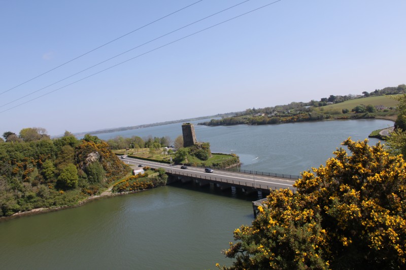
View from the site to the northeast, toward Roche’s Castle and the Slaney Estuary
Archaeological excavations had been undertaken at the site of the ringwork on three different occasions—1984, 1986 to 1987 and 2015. Since then gorse and woodland have overgrown the site and the surrounding land has been used for tillage and pasture.
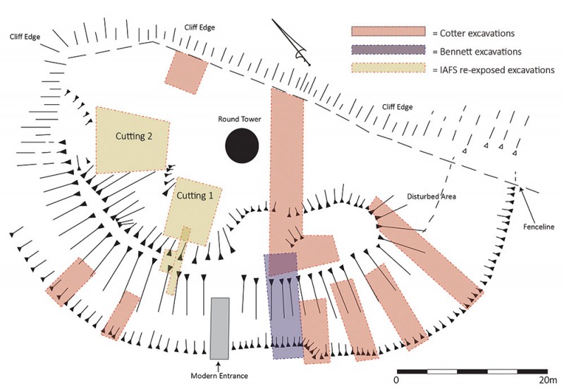
The archaeological excavations in 1984, including one through the ringwork, were conducted by Isabel Bennett prior to the construction of the INHP. A central cutting in the ringwork found burnt material (ash and charcoal) and a mortar rich layer that may be connected to the construction of a stone castle at the site. Vegetation and topsoil removed off the ringwork bank revealed a wall, which Bennett speculated could run across much of the site. Immediately outside the wall five possible postholes were recorded, which were tentatively interpreted as evidence of the original 12th century palisade.
Excavations undertaken at the site by Claire Cotter in 1986 and 1987 were funded by Wexford County Council and the Social Employment Scheme, as part of works within the INHP. The excavations revealed a burnt structure, possibly of sill beam construction, in the western part of the interior dating possibly to the late 12th or early 13th century. The stone footings of a building revealed in the southeastern sector most likely relate to the stone castle or town. The building butted at an angle against the wall previously exposed by Bennett. The excavations showed that the interior of the site had been heavily disturbed, probably during the construction of the mid-19th century faux tower.
More than 1500 artifacts were collected during the excavations. The majority of these were recovered from a midden abutting the western bank. Almost all the finds dated from the later 12th – 13th centuries and included a mix of locally produced pottery and French and English imports. More unusual finds, such as arrow heads, silver long-cross, an iron battle-axe, short-cross halfpenny, barrel padlock etc. were also encountered.
Finally, excavations were also undertaken at the base of the Crimean War Monument (round tower) in 2015 by Emmet Stafford to facilitate the placement of lightning conductor mats for the monument. The excavation was confined to two very discreet cuttings at the base of the war memorial. No archaeological remains were uncovered.

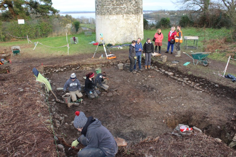
Cutting 1 under excavation, showing masonry features at the eastern (right) and northern extreme of the cutting
In January 2018, the IAFS, under the direction of Denis Shine and Stephen Mandal, commenced archaeological excavations at the site as part of an international field school. Read more
The authors would like to acknowledge the support of all the staff at the Irish National Heritage Park. Claire Cotter has been of great assistance since the excavation started, read through a draft of the paper and kindly gave permission to replicate her site drawing (Figure 2). Finally, thank you to senior supervisor Richard Reid for helping direct the dig and the brave 25 students and interns who completed the inaugural season in January. If you are interested in seeing the excavation it will be active again all June and July 2018. Any inquiries can be sent to denis.shine@iafs.ie.
Bennett, I. 1985. Preliminary Archaeological Excavations at Ferrycarrig Ringwork, Newtown Td., Co. Wexford. Journal of the Old Wexford Society, 10: 25-43.
Colfer, B. 2002. Arrogant Trespass: Anglo-Norman Wexford 1169-1400. Duffry Press, Wexford.
Scott, A.B. and Martin, F.X. (eds.) 1978. Expugnatio Hibernica by Giraldus Cambrensis.New History of Ireland Ancillary Publication No. III. Royal Irish Academy, Dublin.